Aerial archaeology is the study of archaeological leftovers by examining them from elevation. It is one of the oldest prospecting methods. It is very productive and cheap, Aerial archaeology is frequent opinion that an aerial archaeologist is sitting in an aircraft, trying to discover archaeological sites and to take a few good photographs of them.
To perform aerial archaeology you can also use:
Satellite images
Thermal images
Airborne radar images
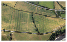
The madvantages of gaining a good aerial vision of the ground had been long appreciated by archaeologists as a high viewpoint permits a enhanced appreciation of excellent details and their relationships within the wider site context.
During early periods investigators attempted to gain birds eye views of sites by:
Hot air balloons
Scaffolds
Cameras attached to kites
Following the invention of the aircraft and Aerial photography archaeologists were able to effectively use the technique to find out and record archaeological sites.
Normally the
photographs are taken perpendicularly that is,
from directly overhead, or obliquely, meaning
that they are taken at an angle. In order to provide
a three-dimensional effect, an additional, slightly
offset, photo may be taken to provide two images
with can be viewed stereoscopically. Aerial archaeology helps to choose a more distinct viewpoint, the
structures become clearer to you and the pattern
becomes comprehensible.
Large sites could
for the first time be viewed exactly, in their
overall and within their landscape. This aided
the production of drawn plans and also stimulated
archaeologists to look away from the discrete
monument and to appreciate a site's role within
its setting. Photos are taken vertically for the
purposes of planning and spatial analysis and indirectly to emphasis certain features or give
perception. Through the process of Photogrammetry,
vertical photos can be converted into scaled plans.
You can also see other methods of archaeology:
Diciplines by Regional study
African ArchaeologyAfrica has the longest record of human activity of any part of the world and along with its geographical extent; it contains an enormous archaeological resource. Scholars have studied Egyptology for centuries but archaeologists have only paid serious attention to the rest of the continent in more recent times.
American ArchaeologyArchaeology of the Americas is the learning of the archaeology of North America, Central America (or Mesoamerica), South America and the Caribbean, which is to say, the pre-history and Pre-Columbian history of Native American peoples.
European ArchaeologyIn terms of area, Europe is the world's second smallest continent, with an area of 10,400,000 km� (4,000,000 square miles), making it slightly larger than Australia.
Medival archaeologyThe period covers the commotion caused by the fall of the Medival archaeology Roman Empire and cultures such as the Vikings, Saxons and Franks.
Near Eastern ArchaeologyNear Eastern Archaeology is a wide generalised application, and is divided into further regional sub-branches, the archaeology of modern states in the region or along broad thematic lines.
Post Medieval ArchaeologyThe Post Medieval Archaeology is considered as a bi-annual journal study of the material evidence of European society. This period saw the conversion of medieval to industrial society.
Modern ArchaeologyIn contrast to the antiquarianism of classical archaeology, anthropological archaeology today is concerned with culture history (i.e., the chronology of events and cultural traditions) and the explanation of cultural processes.